The end of day one had us driving toward our first destination of Lunenburg, Nova Scotia. Each place we stayed two nights and spent the time between traveling ‘back the way we came’ and moving forward toward our next destination. If you look on a map, we flew into Halifax, NS then headed east and south. Our goal was to travel in a big loop all the way south of the peninsula, then return to Halifax for our departing flight.
We pulled into the small town of Lunenburg a bit before sunset. I went into the very busy restaurant, registered for our room, and headed upstairs with our luggage to room #1. Our first two nights in Nova Scotia would be at Salt Shaker Inn & Deli. We unpacked some stuff, then made a beeline for the boardwalk to catch the last of the daylight. This quaint little town was busy with tourists. There were people eating a few feet below our window on a deck, the gulls were flying around making noise, crows were joining in as well, and we could hear cars driving up and down the street on this busy Sunday evening.
The next morning while Marcie was sleeping, I headed down to the wharf to capture some images of the boats in the harbor, boats tied to the docks, and anything that caught my eye. There was a slight mist which provided some allure and moodiness to my shots. The birds were quiet, and the clanging bells from the ships added to the effect. I then made my way back to the room, and Marcie and I walked down to The Savvy Sailor for breakfast. One thing we soon discovered was the places we stayed lacked places to eat for breakfast.
After scarfing down my local organic apple raisin and honey bread dipped in a cinnamon egg batter topped with banana slices and NS Maple Syrup French toast, we hopped in the car and drove back north towards Peggy’s Cove but didn’t quite make it that far. The clouds rolled in and a bit of rain, so we settled on visiting Mahone Bay and as far as the Western Shore. I could also get my very first geocache outside of the United States.
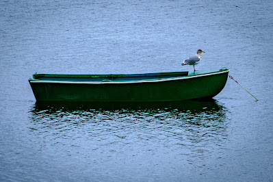
Our next destination was Blue Rocks. I had read many things about this location and was eager to see it. The overcast skies and rough water provided this photographer with a perfect background for a few picture opportunities. On the way back to Lunenburg, I looked out over the water and saw a single green rowboat anchored in the harbor. There were no other boats around this one, and as you can see above, one lone gull sitting at the bow of the boat. I did a quick U-turn and pulled off onto a turnoff. I got my camera out while instructed to “not slam the door to scare him off”, and I complied. I walked to the edge of the water, framed the shot above, and Bam! We returned to Lunenburg and ate dinner at Smokin’ BBQ before Marcie headed back up to the room for a nap.
We headed south and saw Bush Island and Bell Island accessed via Crescent Beach Road. To the left of us was marshland, and to the right was the Atlantic Ocean. We stopped to watch a guy doing doughnuts on the beach with his SUV, two people windsurfing in 3–5-foot waves and one lone lady walking down the beach. The wind was so strong in pushed me and Marcie off our feet. We didn’t fall, but were certainly unstable. Marcie uttered, “they are crazy” about the windsurfers and I agreed.
After entering our warm vehicle and wiping the sand from my lens and our glasses, we left Crescent Beach Road and headed south down highway 332 past Green Bay, toward the LaHave River. There we sat, waiting for the ferry to drive our car across. While waiting for the ferry, a car with three older people pulled up to us. As is customary with Canadians, they said hello and started a conversation. I learned about the ferry being pulled across by a giant cable, about the time the cable broke with cars on the ferry, how the ferry rides are now free, and that “anywhere you are in Nova Scotia you are 30 miles of less from the ocean.” We discussed miles vs. kilometers, liters vs. gallons, monetary differences, Celsius vs. Fahrenheit, and were even given tips on what to see ahead of us.
After crossing the river, we took highway 331 past Broad Cove, West Dublin, Vogler’s Cove and eventually back to Highway 103 and returned to Lunenburg. We walked the boardwalk again, got Ice Cream at Sweet Treasures Confectionery, and returned up to bed for the night. Many well miles traveled and wonderful sights for the day. September 27th ended with the sounds of gulls, boats from the ships, and waves crashing as we were lulled to sleep.
Until next time.
Tim (Kilmer)

Comments
Post a Comment
Love to get your feedback on what you read!